
Basin structure & geometry
Define lateral velocity changes that reveal basin shape and depth to basement.
Non-invasively image basin-wide earth structure to over 10,000 ft (3,200 m) depth, to assist in developing drill targets for producing energy resources in commercial quantities.
Terēan®’s leadership has applied seismic imaging to geothermal exploration for decades — from SeisOpt® and ReMi® development at Optim to fieldwork with the Nevada Seismological Laboratory and Chevron’s exploration imaging.
Deep ReMi® characterizes shear-velocity sections down to geophysical basement using overlapping subsets of instruments, defining the lateral changes that reveal basin structure and geometry — the context you need before committing to a drill target.
Define lateral velocity changes that reveal basin shape and depth to basement.
Locate faults and structural controls relevant to fluid pathways.
Use velocity structure to help prioritize where to drill.
Scale from 24 channels to 120+ channels and DAS fiber.
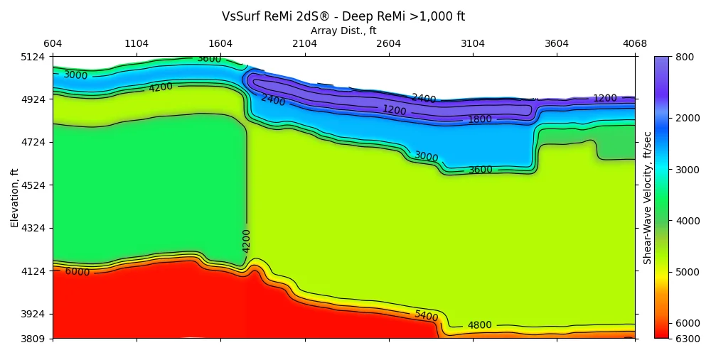
…deep ReMi can characterize shear-velocity sections down to geophysical basement at 1 km depth, using overlapping subsets of instruments and defining lateral changes that allow derivation of basin structure and geometry.
Basin-scale work is project-specific — we’ll help you plan array length and channel count.
Contact us →Have large-array or DAS data? Our team can process it.
Upload data →Selected clients




Talk with a Terēan geophysicist about your site, your data, or the right system for your team.